Fifty miles east of New Orleans, beneath the warm shallow water off the Chandeleur Islands, a retired architect named George Gelé claims he has spent the last fifty years mapping the ruins of a 12,000-year-old city. Sonar imaging he has personally collected since the 1970s shows a single pyramid-like structure rising 280 feet from the seabed — taller than the Great Pyramid of Giza — surrounded by geometric mounds he interprets as the remains of a sunken settlement. He calls the city Crescentis. He has gone on the record to argue that its alignment is “geographically related to the Great Pyramid of Giza in Egypt.” And in March 2026, after five decades of private research, he finally released his findings.
The story has not been confirmed by any peer-reviewed institution. Mainstream archaeologists have, in the careful language they use for these claims, declined to comment in detail. But Gelé’s sonar archive is real, his five decades of fieldwork are documented, and the timing of the alleged civilisation — at the end of the last Ice Age, when the Gulf coastline sat almost a hundred miles further out than it does today — sits exactly inside the window that an entire alternative-archaeology framework has been pointing at for the past thirty years.
Who Is George Gelé?
Gelé is not a fringe outsider. He is a retired architect from Louisiana, trained in the engineering and proportion of large structures, with the kind of professional eye that becomes useful when assessing whether a pattern of underwater shapes is geological or designed.
He has been mapping the same site off the Chandeleur Islands since the early 1970s. For five decades he has personally taken sonar readings, dived the location, collected imaging, and refused to publish — by his own admission, because he wanted the dataset to be complete enough that no one could dismiss it as a single ambiguous scan. His March 2026 release is the result of fifty years of self-funded investigation by one man who is not asking for tenure.
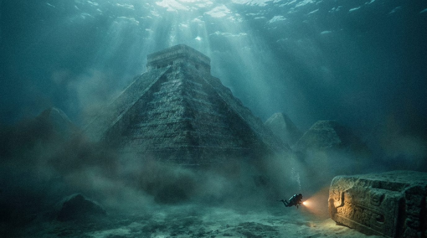
What The Sonar Actually Shows
The central feature of Gelé’s sonar archive is a single colossal structure. By his measurement, it stands 280 feet from the seabed. The Great Pyramid of Giza is 455 feet at its full height — but it was originally built to roughly 481 feet, and erosion plus the loss of its casing stones has reduced it. A 280-foot structure on the floor of the Gulf of Mexico is not a casual rock formation. It is comparable in volume to some of the largest pre-modern stone constructions ever built on land.
Around the central structure, the sonar archive shows what Gelé describes as geometric mounds: regularly-spaced raised features whose shapes he interprets as collapsed settlement remains. The pattern, in his reading, looks like a city.
The site sits roughly fifty miles east of New Orleans, in water shallow enough that diving is feasible but deep enough that the structures have remained out of the casual fisherman’s view for centuries.

Crescentis — Naming The Lost City
Gelé has given the city a name: Crescentis. The naming itself is significant. Researchers who publish negatively-charged claims usually keep their terminology dry — “underwater feature 1”, “site A”. Naming a place is something you do when you believe in it. Gelé believes in it. He has spent fifty years of personal time and money on this single site. The name reads as the act of a man treating his own work as legitimate primary research, not as a hobby.
The Great Pyramid Of Giza Alignment
Gelé’s most consequential claim is geographic. He argues that Crescentis is “geographically related to the Great Pyramid of Giza in Egypt” — by which he means that the alignment, the latitude, or the construction proportions of the Louisiana site share enough geometric overlap with Giza to suggest a common engineering tradition.
This is the part of the claim that makes mainstream archaeologists go quiet. A 12,000-year-old structure off Louisiana with engineering alignment to Egyptian Giza implies that the people who built Giza did not invent that engineering — they inherited it. Which implies a parent civilisation. Which is the exact framework that a long-running alternative-archaeology tradition has been linking to the lost story of Atlantis for nearly a century.
Why The Timeline Is The Smoking Gun
Twelve thousand years ago is not a random number. It is, almost exactly, the date of the end of the Younger Dryas — the brief, brutal cold snap that ended the last Ice Age, melted the continental glaciers within a few centuries, and pushed global sea levels up by approximately 400 feet.
The Gulf of Mexico coastline at the end of the Younger Dryas was not where the Louisiana shore sits today. It was roughly 100 miles further out. Every coastal city, every fishing village, every harbour that existed on the pre-Younger-Dryas Gulf coast is now under water. We know this. It is not controversial.
What is controversial is whether any of those drowned coastal sites contained large stone construction. Mainstream archaeology says no — humanity did not build at scale until thousands of years later. The alternative reading, the one Graham Hancock has been arguing since the early 1990s and the one Gelé’s sonar archive directly supports, says that there is an entire chapter of human civilisational history sitting on the bottom of the world’s continental shelves, and that we have simply never looked for it.
Crescentis would be one of those chapters.
The Wider Pattern Of Underwater Pyramids
Gelé’s site does not stand alone. It joins a growing list of sonar-imaged underwater structures around the world that mainstream archaeology has so far declined to formally investigate:
- Cuba (2001): Canadian marine engineer Paulina Zelitsky and her team imaged what looked like large pyramid-like stone structures 2,000 feet below the Caribbean off Cuba’s Guanahacabibes Peninsula. No academic follow-up expedition has ever been mounted.
- Yonaguni, Japan: a roughly 75-foot-tall stone formation off the coast of Yonaguni Island with right angles and apparent steps. Argued to be a natural sandstone formation by mainstream geology, argued to be an artificial monument by an alternative reading.
- Bimini Road, Bahamas: a long line of regular stone blocks just offshore, dated to a period before any historical Bahamian construction.
- Off Mahabalipuram, India: sonar surveys after the 2004 tsunami exposed temple-like structures matching Tamil oral histories of seven submerged temples.
Each of those sites, considered individually, is dismissible as a coincidence of geology. Considered together — and now joined by Crescentis off Louisiana — they describe a single global pattern: large geometric stone constructions sitting on the continental shelf, dated to the end of the last Ice Age, ignored by the mainstream of the field that should be most interested in them.
Why Mainstream Archaeology Will Not Investigate
The standard mainstream response to underwater-pyramid claims is to point out that academic field expeditions to sites 50-2,000 feet underwater cost millions of dollars, require specialised deep-water teams, and would produce, at best, a confirmation of something the academic consensus is already on record as not believing in. The risk-reward profile for any tenured archaeologist looking at one of these sites is — by their own quiet admission — career-negative regardless of the result. If the structures turn out to be natural, you wasted millions. If they turn out to be artificial, you have just disproved the field’s foundational timeline, and the field will not thank you for it.
So the sites sit there. Crescentis is sitting there now, fifty miles off New Orleans, in water shallow enough to dive without specialist equipment. The reason no expedition has been launched is not technical. It is institutional.

What Happens Next
Gelé has released his sonar archive into the public record. The site is in US territorial waters, fifty miles from a major American port city, in water depths most professional dive operators can handle. The site is not a Cuba-class deep-water expedition. Anyone with funding and a research vessel can visit Crescentis.
Whether anyone will, is the question that the next twelve months will answer.
Either way, an 80-year-old retired architect from Louisiana just laid fifty years of personal sonar imaging into the public record, named a lost city, drew a line from a Louisiana seabed to the Great Pyramid of Giza, and walked away. Whatever else Crescentis turns out to be, the story of how it got onto the historical map is now a permanent part of the underwater-pyramid record.
Frequently Asked Questions
Who is George Gelé?
George Gelé is a retired architect from Louisiana. He spent five decades, beginning in the early 1970s, personally mapping a site off the Chandeleur Islands using sonar imaging and on-site dives. He released his findings publicly in March 2026 after fifty years of private research.
Where exactly is Crescentis located?
The site lies off the Chandeleur Islands, approximately 50 miles east of New Orleans, in the warm shallow waters of the Gulf of Mexico. At the end of the last Ice Age, when sea levels were roughly 400 feet lower than today, this location was dry land roughly 100 miles inland from the contemporary coastline.
How tall is the pyramid?
According to Gelé’s sonar measurements, the central structure rises approximately 280 feet from the seabed. By comparison, the Great Pyramid of Giza is 455 feet at its current eroded height (originally about 481 feet). A 280-foot structure on the Gulf seabed would be one of the largest pre-modern constructions ever identified.
What is the link to the Great Pyramid of Giza?
Gelé argues that the Louisiana site is “geographically related” to the Great Pyramid of Giza — meaning that its alignment, latitude, or engineering proportions share enough overlap with Giza to suggest a common construction tradition. If correct, the implication is that the engineering knowledge used at Giza was inherited from an earlier source, not invented in Egypt.
Has the discovery been peer-reviewed?
No. Gelé’s findings have not been published in a peer-reviewed academic journal and no university or major institution has yet mounted a follow-up expedition. His sonar archive is publicly available; the academic verification, by his own framing, would require an independent expedition that no institution has currently funded.
Are there other underwater pyramids like this?
Yes. Pyramid-like structures off Cuba were imaged in 2001 at depths of 2,000 feet. The Yonaguni Monument off Japan, the Bimini Road in the Bahamas, and structures off the coast of Mahabalipuram in India have all been sonar-imaged or directly observed, and all sit at depths consistent with submersion at the end of the last Ice Age. Crescentis joins this global pattern.
Could the site really be 12,000 years old?
The timeline matches the end of the Younger Dryas, when global sea levels rose approximately 400 feet over a few centuries. If Crescentis was built before the sea-level rise, a 12,000-year-old date is geologically consistent with its current depth. The same timeline overlaps with several oral and written traditions of pre-flood civilisations, including the Sumerian record of eight kings who ruled before the great flood.
Discover more from Infinity Explorers
Subscribe to get the latest posts sent to your email.